SLIDE SETS
Unzen Volcano 1991-93 Eruption

- Unzen Volcano started its eruption on 17 November 1990, following swarms of earthquakes beneath the summit. The initial stage of eruption was characterized by small-scale phreatic eruption. Since February 1991, phreatomagmatic eruption started and became larger m scale with time. After the inflation of the summit area, lava appeared in the Jigokuato Crater, one of the summit craters, on 20 May 1991. (photo by Japan Meteorological Agency on 17 November 1990)

- Unzen Volcano is an andesitic to dacitic composite volcano. It grew about 500,000 years ago on a volcanic grabben formed under the N-S extensional regional stress field. The recent activity has been concentrated m au area around Mt. Fugen. Andesite lava flow erupted from the summit of Mt. Fugen in 1663, and dacite lava flow in the northeastern flank in 1792. Just after the 1792 eruption, a collapse of a pre-historic lava dome named Mayuyama occurred due to intense seismic activity. The avalanche rushed into the Ariake Bay, generating large tsunamis that reached the opposite shore. A total of 15,000 lives lost in this catastrophe. (simplified by Tatsuro Chiba from Tanaka and Nakada: 1988)

- (Upper) Dacite lava dome had grown continuously since May 1991, generating pyroclastic flows which cascaded down along the Mizunashi River in the eastern flank of Mt. Fugen. On 3 June 1991, pyroclastic flows killed 43 people in the evacuated area along the Mizunashi River. Casualties including three volcanologists, Katia and Maurice Krafft and Harry Glicken, were found in pyroclastic surge deposits. (Middle and lower) Both 8 June and 15 September 1991 flows travelled 5.5 km from the source. Pyroclastic-flow deposits extended their distribution area with time. Pyroclastic flows descended along the Oshiga-dani valley (northeast of the dome) and the Akamatsu-dani valley (southeast), respectively. (photos by Kokusai-kogyo Co., Ltd.)

- (Upper) Heavy rain frequently triggered debris flows originating from the newly-laid pyroclastic-flow deposits and the upstream region covered by thick volcanic ash. Debris flows flooded over an area along the Mizunashi River, and the deposits extensively covered farmland and houses near the coast. (Lower) Pyroclastic flows reached the northwestern residential area of Shimabara City in May and June 1993; one person was killed by pyroclastic surge on 23 June 1993. (photos by Kokusai-Kogyo Co., Ltd.)

- Most of pyroclastic flows of this eruption were of Merapi-type, i.e. they are generated due to simple gravitational collapse of lava blocks from the margins of the lava dome. Looking from the southern side of the Akamatsu-dani valley, these sequential photographs show a pyroclastic flow moving toward the viewer. Turbulent ash-cloud, which appears to be sliding on the ground, had moved silently. (photos by Hiroshl Shimizu on 19 March 1992)

- As lava blocks are detached from dome front, these materials are broken into smaller pieces, similar to the action of building demolition by dynamite. The shocks of landing and collision triggered sudden expansion of high-pressure gas sealed within the pores of the lava dome. Cuntinuous effusion of gas from lava pieces during movement probably produces fluidal movement of pyroclastic flow. Successive rockfalls observed here have induced relatively large flows. The frontal cliff of lava dome in this photographs is about 50 m high. (photos by Tadahide Ui, on 2s February 1992)

- Pyroclastic-flow deposits are composed of a main part (block-and-ash flow deposit) and a peripheral part (pyroclastic surge deposit). The former fills river and valley bottoms, while the latter is found mainly on relatively higher places. This slide shows the Kita-Kamikoba area devastated by the 15 September 1991 pyroclastic flows. The desert-like foreground comprises of pyroclastic surge deposits, while the background are primarily block-and-ash flow deposits. (photo by Setsuya Nakada on 23 September 1991)

- �Pyroclastic surges moved at speeds of over 50 meters per second, and toppled down trees and threw cars as far as several tens of meters. They were so hot that wood surface were carbonized. This photograph shows the site of a house in Kita-Kamikoba, which was attacked three times (3 and 8 June, and 15 September 1991) by pyroclastic surges. The house was burned on 3 June, and the debris were carried away by the subsequent surges. (photo by Setsuya Nakada on 23 September 1991)
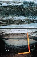
- (Upper) Thick block-and-ash flow deposits covered Kita-Kamikoba area. However, the distribution of these deposits may have varied from place to place as evidenced by the vinyl cover on the ridges of a tobacco field which have remained intact. A 30 cm-thick layer of block-and-ash flow deposit, partly covered with dry mud and just above the pyroclastic-surge deposit filling between ridges (behind hammer-head), represents the deposits produced on 8 June 1991. The 15 September 1991 block-and-ash flow sequence forms the meterthick middle layer which exhibits significant color changes from dark gray to brown going up the deposit. This color change is due to oxidation just after deposition. The topmost gray layer is debris-flow deposit. (Lower) At Kita-Kamikoba, pyroclasticsurge deposit covered higher parts around block-and-ash flow deposit. The bottom 5cm-thick layer is the surge deposit of the 3 June 1991 flow. The overlying 10 cm-thick layer, whose color changes from gray to yellowish upward, is the 8 June surge deposit, which was later eroded by the 15 September surge. The reddish tephra on the top is an airfall. Cross-section of sun-cracks filled with gray ash can be seen in the 8 June deposit. (Upper photo by Setsuya Nakada m April t992, and lower by Tadahide Ui m December 1992)

- �Photograph shows the eastern view of Unzen Volcano. The new lava dome (with a smoke) caps the summit of Mt. Fugen and thick apron of pyroclasticflow deposits on the flanks. A large amphitheater on the Mayuyama dome, produced during the 1792 collapse, faces the Shimabara City. A hummocky surface and islets of the debris-avalanche deposits can also be seen (lower right). An active fault runs through the middle of this photograph, from the cliff on the lower left of the active dome toward the viewer. Debris flows which overflowed over the Mizunashi River, descended along this fault. (photo by Asia Air Survey Cu., Ltd. on 20 January 1992)

- �At night time, incandescent lava fragments cascaded down from toes of lava dome. Occurrence of pyroclastic flows could also be detected by seismometers. The maximum daily count of pyroclastic flows using seismic record is more than 50, and the total number of pyroclastic flows which have occurred since May 1991 until the end of 1993 is about 8,600. (photo by Nagasaki Photo Service e Co., Ltd. on 2 October 1991)

- During the rainy season, heavy rains frequently caused debris flows which overflowed toward the coastal area along the Mizunashi River. The total number of houses damaged by debris flows has reached more than 2,000 during the first 2 years. Three large ponds were constructed as repository of debris along the overflowing course of the 30 June 1991 debris flows. In the 1992-summer and 1993-spring, however, debris flows descended along the main stream of the river. (photo by Nagasaki Photo Service Co., Ltd. on 3 May 1993)

- Debris flows blocked main roads and widely covered farmlands. Near the mouth of the Mizunashi River, where the slope is gentle, thick debris are deposited such that only the roof of houses protrude from the thick debris. One debris-flow event is capable of moving about one million cubic meters of debris. Soon after this photograph was taken, a paved road was constructed on top of these deposits. (photo by Setsuya Nakada on 3 July 1993)

- This shows a cross-section of debris flow deposits exposed in the Mizunashi River. The deposits contains blocks and lava fragments not only derived from the newly emplaced lava dome but also from altered lava fragments of older deposits. Vertical "stripes", which are predominantly made of relatively coarse-grained material, have developed at the upper surface of the deposits. This structure is similar to a fumarolic pipe but fine-grained particles have been selectively removed by water draining from the surface. (photo by Setsuya Nakada on 16 September 1992)

- �Since May 1993, pyroclastic flows started to descend toward Senbongi, a residential area northwest of the Shimabara City . Relatively large-scale pyroclastic flows have been deposited in this area on 23 and 24 June 1993. This photograph shows the frontal view of a turbulent ashcloud of pyroclastic flow which occurred m the early morning of 24 June. The movement of this cloud stopped just 200 m in front of the photographer. (photo by Nagasaki Photo Service Co., Ltd. on 24 June 1993)
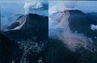
- The June 1993 pyroclastic flows were funneled through a narrow gorge and attacked the Senbongi district. Ash clouds expanded from the mouth of the gorge. The pyroclastic surges travelled about 1 km longer than the main flows (block-and-ash flows). The topography along the path of these surges appears to have controlled their force. Both photographs show the scenery of the Senbongi district before and after the pyroclastic flow events. (photos by Nagasaki Photo Service Co., Ltd.)
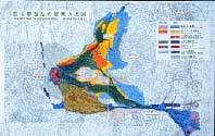
- This diagram shows a disaster map of this eruption drawn with the aid of aerial photographs taken on June 1993. The northeastern part of the lava lobe which had grown enormously collapsed on 23 and 24 of June 1993, and relatively large pyroclastic flows were generated reaching the Senbongi area (upper part of the diagram). On 26 June, The southeastern part of this lobe collapsed, producing a pyroclastic flow which ran eastward (towards the right) beyond Route 57. A wide area (light blue color) was burned by ash-clouds from these pyroclastic flows. Pyroclastic flow (black-and-ash flow) deposits produced from these events are colored dark green, and the growing lava dome appears red.(Tatsuro Chiba, Asia Air Suney Co., Ltd.)
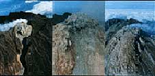
- The lava dome had grown since May 1991, and the dimension had increased to about 1 km long, 800 m wide, and 200-400 m high, by the end of 1993. The lava dome consists of multiple lobes of massive lava surrounded by crumbled breccia. The lava dome (lobe 2) grew like a rose flower in the eastern slope of Mt. Fugen during the early stage of the eruption (left). The largest lobe (lobe 11) started to grow near the top of the dome in March 1993 (center). Lobe 11 had wrapped around the eastern half of the dome by the end of 1993 (right). (photos: left, by Setsuya Nakada on 16 June 1991, center, by Takeshi Malsushima on 3 April 1993, and right, Osamu Oshima on 2 December l993, respectively).
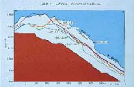
- The volumetric calculation for lava dome, pyroclastic- and debris-flow deposits was done using maps produced from aerial photographs. This diagram shows the temporal changes in the topography along the east-west cross-section of lava dome and talus deposits in the summit area. The growth of the lava dome and erosion by rockfalls can be read from this diagram. (from the data of Geographical Survey Institute, Japan)
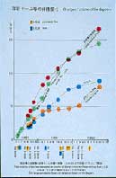
- The total volume of effused lava since May 1991 had reached 0.17 cu. km. by the end of 1993. About 40 % of this value forms the lava dome at the summit. The average rate of eruption during this period is roughly 6 million cu m. per month. (from the data of Geographical Survey Institute, Japan)


